As our Town has grown and expanded, various changes were needed. One of the changes many people are not aware of, and know of, only if they lived through the change, is the improvement in our roads. No, I’m not speaking of potholes and like things, I’m talking of rerouting an existing route. Kind of like listening to the line out of the Dukes of Hazzard theme… ”straightening the curves” and making it happen.
The early roads simply followed the easiest route available for people and equipment to move along. Many began as footpaths between individual farms. Steep inclines were to be avoided if you had a heavy load with a team of horses. You found a way around this natural formation. If there was a stream, a shallow place was needed to wade across or a bridge had to be constructed. In the case of low areas, where rain runoff would accumulate turning the dirt into mud, trees or planks would be placed down to allow wagons to get across. Thus, we had plank roads.
 Now, we all know nothing is free, regardless of what certain politicians proclaim. So, enterprising individuals and towns took over the maintenance of sections of these roads, keeping the wood planks it good order. To cover expenses for this upkeep, toll houses were erected to collect funds from those using the trail. In previous articles, I’ve made mention of these toll houses, so I won’t go into the details here.
What I do want to bring to the attention of the younger members of our community is how our roads changed with the advent of the automobile. As early motorized vehicles became the norm, a marked increase in speed was available and the new age driver wanted better roads to take advantage of the wind whipping through their hair as they glided down life’s highway.
Constant grading and smoothing of the dirt roads, which soon became rough again, was eliminated with asphalt and concrete paving. Then, why not modify the grades, lower the hills, and raise the low areas? And, next? Straightening out the curves.
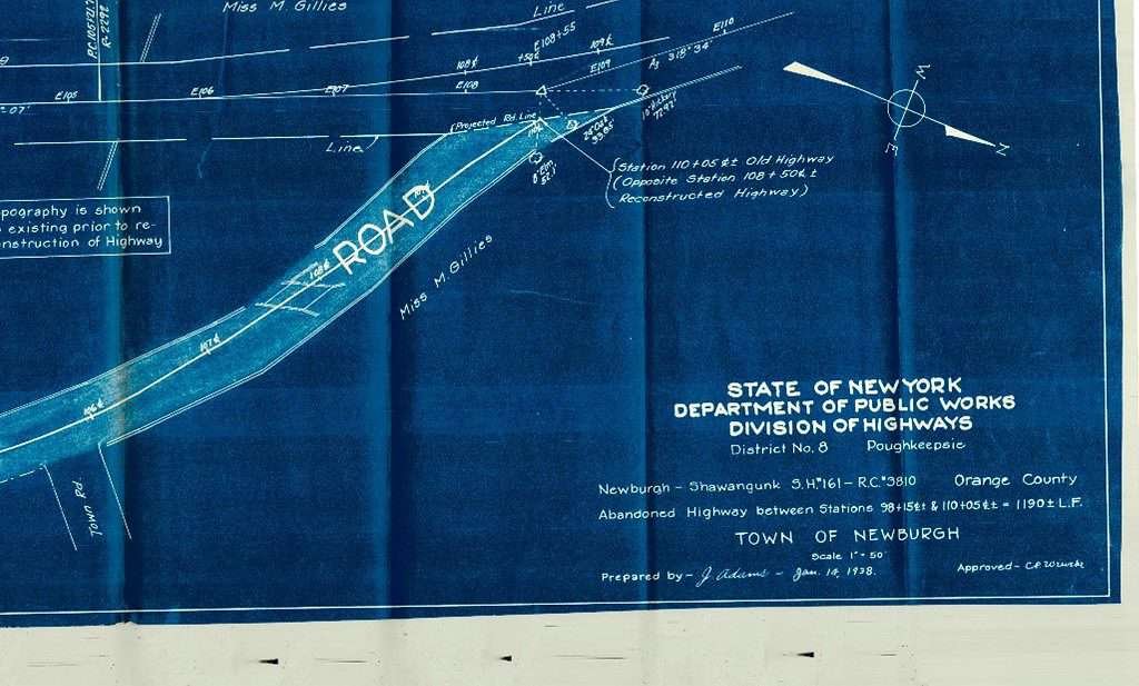
Going through old records, I discovered blueprints from 1938, where North Plank Road was redirected, in one section, eliminating the old, abandoned toll house and straightening out the highway. What I’m referring to is the small section now named the Old North Plank Road where the Golden Rail Ale House is located.


Many of you don’t know this loop was the original direction the road took until 1938 when the land was purchased from Miss M. Gillies and a culvert was installed to allow the water to flow beneath the highway. This change allowed traffic a more direct option in travel. Looking over the 1875 map, you’ll see one of the various ways the Gillies name was spelled by others, based on the way they heard it and thought it was spelled, Gillis. Anyone delving into genealogy learns early on the tricks to search out information by modifying the spelling of surnames.
Also, after this change in direction was completed, some of the area was filled in, leveling out the area on the south side of the stream, and the north side of North Plank Road. The old toll house and adjacent building were renovated, eventually becoming a favorite oasis of many Town residents.
In the decades to come, perhaps some intrepid individuals will be digging and come upon a section of old highway buried beneath their current ground level, leaving them to wonder what they had unearthed, and just whose footprints may have been visible at one time in the dust.